GIS on Macs
Until fairly recently, you couldn’t really put Macintosh and GIS
in the same sentence without a sense of embarassment.
But now the combination of a substantial body of mostly free software,
plus the ability to run Windows for the market-dominating commercial products
from ESRI, MapInfo, etc., makes a Mac a fabulous platform for
GIS, remote sensing, cartography and scientific visualization.
Some worthwhile free software for OS X
- QGIS—good feature set
(especially for vector data), good ease of use, decent documentation (although usually a tad behind releases).
As of October 2018, the current cutting-edge version is 3.6.1 ‘Noosa’, and requires El Capitan or later, along with Python 3.6.
(Downloads used to be from the kyngchaos site below, but are now directly from the qgis site.)
- SimpleDEMViewer—for rendering elevation data
in a variety of formats. Version 6.5 (Feb. 2019) requires 10.11 (El Capitan) or newer; Version 5 requires 10.8 (Mountain Lion) or better.
- MultiSpec—a very
useful application for viewing and analyzing remote sensing raster data.
For the command-line
The Unix side of the Mac has some valuable programs (you really should have at least the first two):
- GMT—superb software in the best Unix tradition: a free,
task-specific (in spite of the name ‘Generic’ Mapping Tools) group of small programs for creating maps,
graphs and visualizations. Because it is command-line driven, GMT can be frustrating if you don’t use it for a while,
and have to re-learn the commands. Decent manual, but make your own instructions for the tasks you use most often.
Downloads are at https://gmt.soest.hawaii.edu/projects/gmt/wiki/Installing.
- GDAL/OGR—for translating, reprojecting and extracting both raster and
vector formats; sometimes included (as a framework) within other software. Starting with version 1.9 (it is now at 2.4.1, although available Mac versions are a bit behind),
GDAL/OGR adds the welcome ability to manipulate data in the ArcGIS .mdb format.
- GRASS—massively powerful
GIS software, but also difficult to learn and use.
Slowly adding a GUI, and can be integrated with qgis. (In fact the current version of qgis includes
an embedded version of GRASS.)
- PROJ.4—for reprojecting data; usually included (as a framework) within other software—you will probably not need to download it separately.
These, and more, are available through the fink project and MacPorts, admirable efforts which try to simplify the installation of Unix-based software for the less-geeky user.
In large part they succeed; but the sacrifice one makes in using them is that they often lag behind current versions.
Probably the most important single site for Mac GIS software is William Kyngesburye’s kyngchaos website.
In addition to valuable information on how to compile software on OS X, he offers reasonably up-to-date binaries of many programs,
including grass, PostgresSQL, gdal and proj (note that qgis is now handled by qgis.org). Thank you, Mr Kyngesburye.
Windows-y
If you are running Windows on a Mac, several of the above are available for Windows; in addition you should look at Windows-only free software such as:
- MicroDEM—powerful,
and frequently updated, but the interface is a bit eccentric.
- Spring—seemingly a rather full GIS from Brazil, but I’ve barely used it.
- ILWIS—another full-featured GIS, but again I have very little experience with it.
Not worth the trouble?
- Jump (in any of its multiple guises)—although it has many good features for cartography,
Jump was for a long time too buggy on Macs, although these have largely been ironed out;
re-projection capability has only recently been added.
In its favor, it does have pretty good object editing capabilities. Find out more at OpenJump.
- Landserf—also not ready for prime time. It has, to me, a confusing interface, but it does offer substantial raster-image analysis features. Has been dormant for several years.
- uDig—a slowly-improving GIS that lags behind Qgis.
If you are taking GIS classes at high school or university then you will probably want to use the same software selected by your school.
MultiSpec can do much of the classification and other raster analysis that the big boys can do, but if you have assignments, chances are that your graders will be looking for the numbers produced by the official software—those produced by MultiSpec may be just as valid, but they may be slightly different, and a grad student poring over a hundred assignments will be reluctant to listen to your explanation of why your answers are a bit unusual.
But for learning the intricacies of remote sensing, or producing an analysis which does not have to match ‘the’ answer, free software can do much of what commercial products can.
And approaching assignments via different software can help you to really understand both the problem and the answers.
Hints on data
As you collect more and more data for your GIS and remote sensing explorations,
you will experience a common problem: organisation. Many gigabytes, many regions, many data formats
and many projections will lead to many confusions if you don’t watch out. Some suggestions:
- Keep track of your data sources. Even if you download all available metadata and explanatory
information, there will inevitably be questions arising from your data use.
Well-organised bookmarks will repay the time spent in keeping them sorted and commented.
(And don’t forget to back up your labour-intensive bookmarks.)
- Always have information about the data’s projection to hand.
Name the folder containing the data with the projection (or lack thereof – I have lots of
folders whose name includes WGS84, flagging the enclosed data as lat/long WGS84).
Far too much data are distributed without .prj files or with incomplete metadata. Some software will
re-project ‘on the fly’, but it still needs to determine what the data’s
projection is. Take the time to learn ogr/gdal well enough to create a missing .prj file.
- Keep track of how you are using your data: what projections are good for particular regions or
countries; what level of detail in your data is suitable for which map scales.
Good parameters for projections are hard to come by; write them down.
- Balance the data resolution with your map’s purpose. The Natural Earth Data 1:110,000,000
files aren’t going to be of much use for a full-page map of Rhode Island,
nor does it make sense to use high-resolution GMT data for a quarter-page map of
the entire globe.
Links
Some important general sites:
For those especially interested in elevation data and visualization, these three sites are superb:
And here are some major global data sites:
- Natural Earth Data This recently-developed small-scale dataset is
a “public domain map dataset available at 1:10m, 1:50m, and 1:110 million”, and includes both vector and
raster data, all designed to work together using shapefiles and TIFF (with tfw), geographic WGS84, and with reasonably
good attributes. This belongs in your library, unless you only work with large-scale maps.
- Diva-GIS data Higher resolution than the Natural Earth Data, these data
are from the website of Diva-GIS, a gis program aimed at Windows.
You can download individual countries (in several layers), as well as global and regional data.
Like the above, these are shapefiles, geographic WGS84. Although it is difficult to tell from the website, this data
may be derived from GADM data (www.gadm.org), which would put it in the category of non-commercial use only.
- Open Street Map This is a
collaborative effort to provide an alternative to Google Street Maps and other
commercial data. Some degree of trust is required, as you do not know the skills
of the people who created the data, but on the whole OSM seems quite acceptable.
Data in OSM format is available from planet.openstreetmap.org (22 gigabytes for
everything!); a separate shapefile of the globe is also available.
OSM data is updated frequently, but it is difficult to find out what changes have been made
if you are using shapefile versions, so you will need to re-create your maps each time you update the data.
Make and use stylesheets! Country and regional downloads, in both OSM and shapefile formats, are available from
download.geofabrik.de and others. BBBike provides city-focused files at http://download.bbbike.org/osm/.
There has been considerable discussion over the September 2012 change to the OSM license; it does seem a bit strange – can you really
assign copyright to a group of unnamed people?
- 30-second data at UCSD Topography
(derived from SRTM 30-sec data and GTOPO30 for high latitudes) and bathymetry (derived from Smith and Sandwell
global 1-minute data for bathymetry plus others) at the standard of medium-resolution data, 30 seconds
(roughly a kilometer at the equator). You can also extract a region of interest. This is the highest-resolution
global dataset which includes both topography and bathymetry (and even then the bathymetry is cheating).
It is quite true that we have better terrain mapping of the surface of Mars than we do of
our own planet beneath the waves.
- CGIAR global topography This dataset is of topography only,
but at very high resolution, 3 arc-seconds (90 metres), again derived from SRTM data,
downloadable in 5-degree tiles, and covering most of the globe.
Also available downsampled to 250m and 500m resolution.
- Aster GDEM This dataset is also topography only,
derived from ASTER
(Advanced Spaceborne Thermal Emission and Reflection Radiometer) satellite data. The GDEM (Global Digital Elevation Model)
covers global topography between 83°N and 83°S, and claims to be 1 arc-second (30 metres), but the initial distribution in 2009
was widely regarded as of considerably less resolution, and contained substantial numbers of artefacts.
Version 2, released late 2011, was vastly better, and may indeed be 30 metre resolution. Version 3 apparently was issued in 2013, and claims improved void-filling
and fewer water-body irregularities. It continues to be distributed in 1-degree tiles. See https://lpdaac.usgs.gov/news/nasa-and-meti-release-aster-global-dem-version-3/
for an official news release. Also new is the raster data ‘ASTER Water Bodies Database’ (ASTWBD), which categorises water as ocean/lake/river.
In comparing GDEM v1 with v2, (see illustrations below)
the older has an overall ‘out of focus’ look, and has many more (and larger)
artefacts: for example, the ‘worm tracks’ in the center of the peninsula; and pits in the lower region.
The small island off the northern tip has become bloated.
The entire outline shrinks several pixels in the new version, and tiny islands appear which are not seen on the old version.
Data is available in 1-degree tiles, each 3601 by 3601 pixels. Geographic Lat/Long, WGS84. The names of data tiles refer to the latitude and longitude of
the geometric center of the lower-left corner pixel. Open the
dem files in whatever program you use to render DEMs (the examples below use SimpleDemViewer).
The datafiles used to be available from the EarthExplorer site in the US, as well as
the recently-introduced (and amazingly inept) earthData site (also US-based).
The data now appears to be distributed through the ‘AρρEEARS’ interface at https://lpdaacsvc.cr.usgs.gov/appeears/products,
but the USGS sites are now so messed up that I have not yet been able to find out how to obtain the data. Data distribution from Japan is from
a glacially-slow and convoluted interface at https://gdemdl.aster.jspacesystems.or.jp/index.html. The entire dataset is distributed from
https://e4ftl01.cr.usgs.gov/ASTT/ASTGTM.003/2000.03.01/ but this is a command-line interface, so you must know the tiles you want to get beforehand.
Most US sites (including this one) have switched to mandatory registration (free) in order to download data.
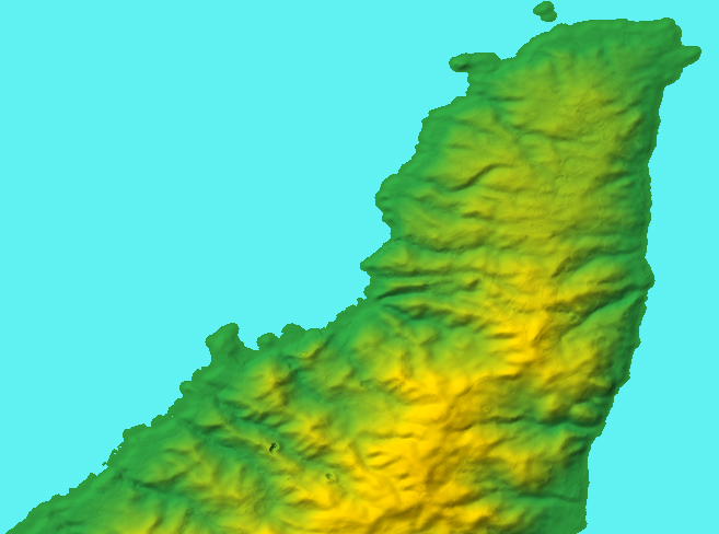
The first version of GDEM data – the location is the northern tip of Sado Island, Japan.
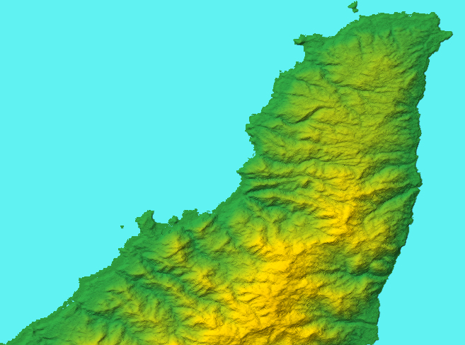
The much-improved second version GDEM data. (Original filename: ASTGTM2_N38E138.)
- GMTED2010 A major recently-released source
of elevation data, the Global Multi-resolution Terrain dataset is available in 30-second, 15-second and
7.5-second resolutions, in seven different versions for each (start with the systematic subsample (dsc)
and maximum (max) versions – the latter especially if you are dealing with coastlines, otherwise there are lots of holes).
Unfortunately, the USGS is doing another of its sillinesses, and distributing these as uncompressed files;
the 7.5-sec data files are a massive 250MB+, many times larger than a zipped download would be. The 30-sec data is of
considerably better quality than previous 30-sec data (e.g. GTOPO30).
Here are the GMTED tiles; they are named for latitude first, then longitude, of the lower left corner. For example,
New Zealand is in S50E150; most of Spain is in N30W030. A different, in some ways better, interface to this data is at
EarthExplorer, which feeds tiles in zipped format (though you get all
seven at each resolution selected). EarthExplorer requires registration (free), but it is worth doing.
Comments?
If you have any comments, please send e-mail to:
geog at-sign oh-no-not-again dot info.
TOP